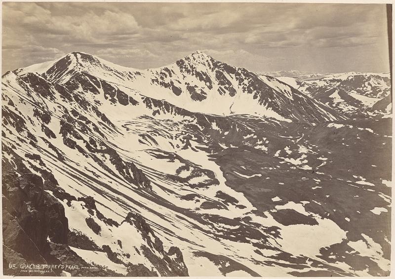
A panoramic view of the front range of the Rocky Mountains, from near Gray's and Torrey's Peaks
Jackson, William Henry, 1843-1942 · 1873
A panoramic view of the front range of the Rocky Mountains, from near Gray's and Torrey's Peaks sweeping the horizon in every direction, and including the 360° in the above six views, which can be joined together as one. The area embraced is about one hundred and fifty miles in diameter, extending from Long's Peak on the north to Pike's in the southeast, to Mount Lincoln in the south, and the Blue River Mountains to the west. The stand-point is upon McClellan Mountain, a spur running northward from Gray's Peak, extending eventually down to Leavenworth Mountain, back of Georgetown. There are several rich mines upon it, at an elevation of 12,000 feet, and upon the summit, in the bare spaces among the snow-drifts, are frequently-occurring stakes, marking some one's "claims." hi the first view, No. 65, are the twin peaks, Gray and Torrey, named from the two collaborators in science, who have done so much for their cause, among these mountains. They are very nearly of equal height, Gray being 14,341 feet and Torrey 14,336. From peak to peak the distance is nearly a mile, and through this saddle is a "pass" from Georgetown to the mining-towns on the Blue River. The trail runs up the long ridge toward Gray, and then turns to the right. Its course can be seen by looking sharply where the snow-banks cut across it. The combing crest of snow at the summit frequently lies all summer, and it then becomes necessary to tunnel under it, so that the pack-animals may pass over. To the right of Torrey, away in the distance, across Middle Park, are the Blue River Mountains, their glittering snow-fields alone making them visible. (Jackson, 1875)
Sign in to order prints, canvas, and more of this work. Browsing and full-resolution downloads stay free.