Digital Commonwealth — Springfield College Archives and Special Collections
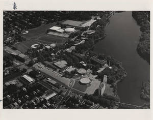
Aerial photograph of Springfield College campus
[2012?–2017?]
An aerial photograph of the Springfield College Campus between the years 2012-2017. This image shows the whole campus from Sheffield St. to the graduate village. It seems to be after the tornado in 2011 as there are only a few trees around the power house. Lake Massasoit is also shown. There is handwritten "Beach" with an arrow to an exposed part of the land by Gulick Hall. It seems like this was a joke as there was not supposed to be a beach there, but may have been a result from tornado damage. On the image is handwriten in white, "Beach" with an arrow pointing to the exposed part of land by Gulick Hall.
🔒
Order museum-quality prints
Sign in to order prints, canvas, and more of this work. Browsing and full-resolution downloads stay free.