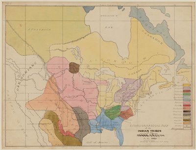
Ethnographic Map of the Indian Tribes of the United States, A.D. 1600
Seth Eastman · 1849–55
This map of Native languages is based on one by Albert Gallatin (1761-1849), a geographer and diplomat who was the first to classify these linguistic boundaries, in 1826. The vivid colors (Minnesota is pink) are especially well preserved. Map-making had always been Seth Eastman’s love. He even wrote a textbook on topographical drawing used at West Point, his alma mater. This watercolor, one of 35 works on paper by Eastman in Mia’s collection, was the basis for an illustration in Henry Rowe Schoolcraft’s massive Historical and Statistical Information Respecting the History, Condition, and Prospects of the Indian Tribes of the United States (Philadelphia: Lippincott, Grambo & Co., 1851-57).
Sign in to order prints, canvas, and more of this work. Browsing and full-resolution downloads stay free.